

Programs + Presentations
Flash Foxy Trad Fest • MAMMOTH LAKES • Sept 12-14, 2025
presented by Patagonia with support from Mammoth Lakes Tourism
These programs are included with your festival pass, just show up!
Select events are open to the public. See descriptions for more details.


Friday @ 5:30PM
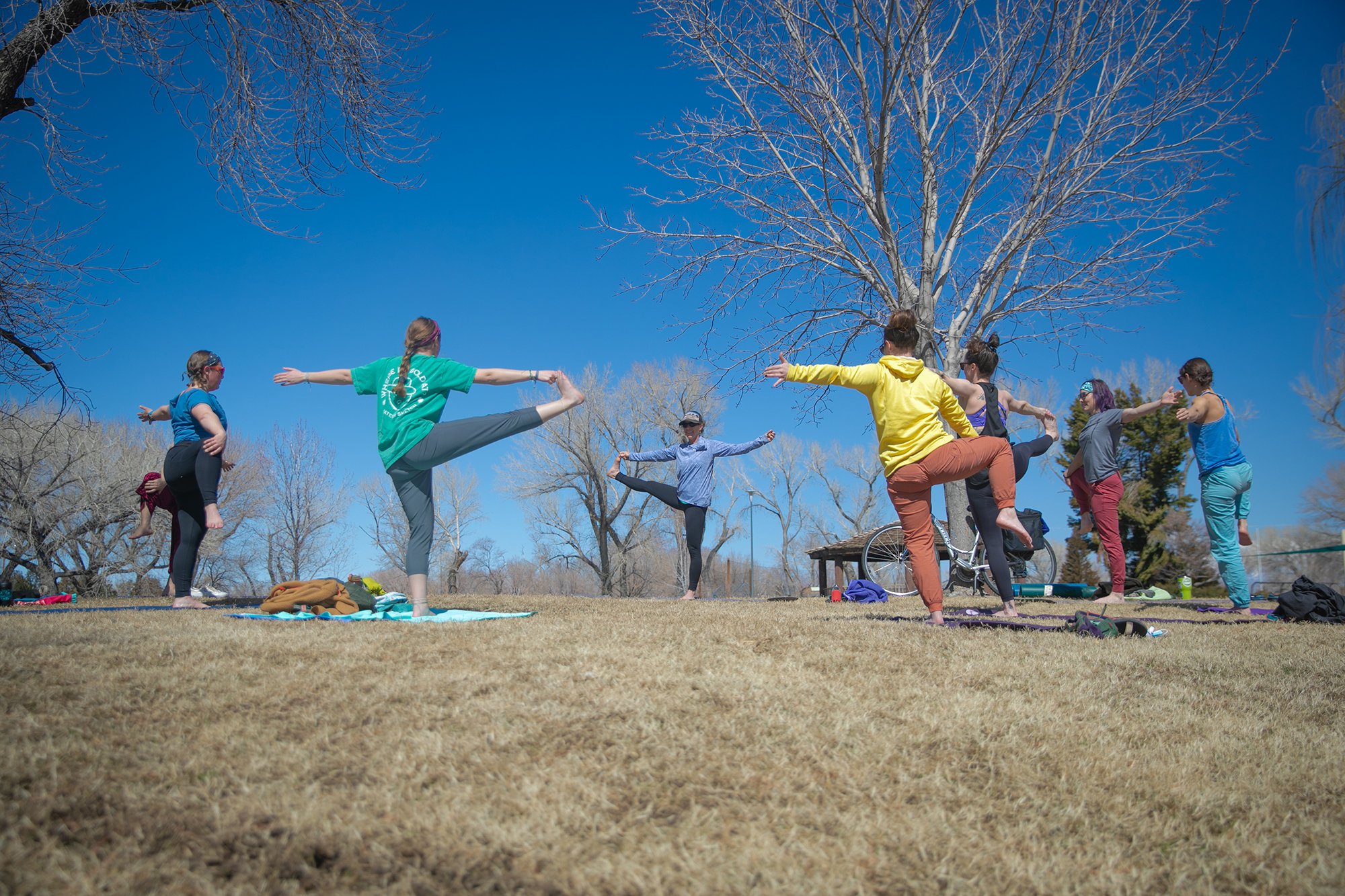
Location: Mammoth Creek Park - Pavilion
Get groovy while DJ Fixher spins sweet tunes!
THEME: Nowhere to wear it! Your old prom dress still fits? Fur coat? Leather pants? Your coziest onesie? Fishnet stockings… this is your chance to wear that thing hiding in the back of your closet that makes you feel fab!
DANCE PARTY with dj fixher

Friday + Saturday
GARMENT + GEAR GLOW UP STATION
Location: Mammoth Creek Park - Pavilion
Bring your torn, worn, tired, drab, and dysfunctional clothing + gear for a Flash Foxy glow up! Stop by the station to get tips and hands-on DIY expertise from local mender Colton Johnson (he/they) to help keep your gear going longer. We will provide materials to mend, patch, beautify, and upgrade your wardrobe and equipment!

Friday + Saturday
Foxy Friends Gear Swap!
Location: Mammoth Creek Park - Pavilion
Out with the old, and in with the new to you ;). Whether you don’t like the color, it no longer fits, or you just don’t have use a for it anymore— bring your gear that’s still kicking and swap with your Foxy Friends for new favorites.
*Any gear left over at the end of the gear swap will be donated to a local gear library!

Saturday @ 9:00AM
with Katie Lamb (she/her) - presented by Patagonia Worn Wear
Location: Mammoth Creek Park - Patagonia Worn Wear Trailer
Details coming soon.
TEA TALK: FIX IT + ITS YOURS!

Saturday @ 9:00AM
Location: Mammoth Creek Park - Pavilion
Details coming soon.
TEA TALK: QUEER ECOLOGY OF THE SIERRAS
Saturday @ 10:00AM
Location: Mammoth Creek Park - Pavilion
Details coming soon.
TEA TALK: Bystander intervention training


Saturday @ 5:00PM
Location: Mammoth Creek Park - Pavilion
Come together before dinner to collect you breath and realign your body so you’re ready for more sending on Sunday! Details coming soon.
Dinner will be served after the practice.
Evening Yoga


Sunday @ 9:00AM
with Friends of the Inyo - presented by Arc’teryx
*This event is FREE + OPEN TO THE PUBLIC
Location: various, meet at Mammoth Creek Park - Pavilion
Join us for one of our fav parts of the weekend, our MASSIVE Stewardship Project facilitated by our partners at Friends of the Inyo! We think it's necessary and important to give back and take care of the lands on which we recreate. We hope that you will join us in blowing away our community partners with how many of our attendees care about taking care of these lands.
Project details coming soon!
*If you are taking a SUNDAY CLINIC: Make sure you sign up for a stewardship project near your clinic location!!!
Stewardship Project


Climbing Areas
The Eastside offers plentiful options for trad climbing, sport climbing, and bouldering year-round! Here are a few crag ideas to get you started - all located within a 1-hour drive from our festival venue. Remember, all climbers are responsible for managing their own risk. Trail conditions may vary and Flash Foxy cannot guarantee accessibility of any climbing areas. Please read all parking and land use regulations carefully. Participants are responsible for paying day use fees and obtaining any necessary climbing permits.
-
Google Maps: Lake George Parking *16-minute drive from our festival venue!
The Lake George Recreation Area trailhead gives access to some of the best climbing in the Lakes Basin. Dike Wall and Horseshoe Piles have a great collection of single pitch sport climbs in the 5.8-5.12 range while Crystal Crag has climbs ranging from short sport routes to multi-pitch alpine excursions. In addition there are a number of newer sport areas that will keep you busy for some time.
Distance + Directions: From the town of Mammoth Lakes head south west along Lake Mary Road. As the road winds up into the lakes basin look for a left turn at Pokonobe Marina. Follow this left turn through a campground and over a bridge. After crossing the bridge take a right and continue to the trailhead parking.
Approach + Trail Surface: mild-moderate uphill on packed dirt/sand/gravel mix
-
Google Maps: Horseshoe Lake Parking *20-minute drive from our festival venue!
This quiet alpine lake setting above the town of Mammoth features sport and trad climbing at 10,300 feet in elevation. Plenty of climbs from 5.8 - 5.12, with top access anchors. This point is visible from many places around Mammoth.
Distance + Directions: 25 minute drive from the Mammoth Lakes Welcome Center. Take highway 203 towards Lake Mary. Follow the road (past the Lake Mary turnoff) to a large parking area at the end near Horseshoe Lake.
Approach + Trail Surface: ~40-60 minutes of hiking. Terrain can be steep and technical over talus, boulders, and packed dirt/sand/gravel mix.
-
Google Maps: Rock Creek *25-minute drive from our festival venue!
Rock Creek features sport climbing, trad climbing, and bouldering on incredible Sierra granite at around 7,500 feet in elevation.
Distance + Directions: 20 minute drive from the Mammoth Lakes Welcome Center. Take the 395 South from Mammoth Lakes to Tom’s Place. Take this road south into the canyon and the formations will appear on the west side of the canyon.
Approach + Trail Surface: moderate-steep uphill 0.2-1.5 miles on trails and talus.Trails between climbing areas are on mixed terrain including talus, boulders, packed sand and soft sand.
-
Google Maps: Tioga Road Parking *35-minute drive from our festival venue!
This area is situated at the northern end of the Sierra Eastside, and is unique in its nature given that it has some of the most easily accessible sport, trad, bouldering, and ice climbing on cliffs that are more often than not empty. Perhaps climbers are too eager to get to the better known climbs in Tuolumne Meadows, but make no mistake the climbing to be found west from Lee Vining along the Tioga Pass is worth a visit or two.
Distance + Directions: From the US 395 take the CA120 west toward Tioga Pass and Yosemite National Park to reach all the climbing. All the areas are located in a 10 mille stretch West of the 395/120 junction.
Approach + Trail Surface: moderate-steep talus downhill to crag. Some areas require a rappel to approach.
-
Google Maps: Pine Creek Canyon *45-minute drive from our festival venue!
Pine Creek lies in a stunningly scenic granite canyon nestled between Mount Tom & the Wheeler Crest. This once backwater area has now grown into a truly world class destination. Pine Creek now features over 630 routes including long multi-pitch affairs, plentiful traditional climbs, and one of the largest collections of sport climbs in the state!
Distance + Directions: Take Hwy. 395 North from Bishop to Pine Creek Road. Turn left onto Pine Creek Road. Continue through the town of Rovana and several switchbacks until you see Sheelite Canyon (the obvious deep canyon) on your right. Just across from the Campground, take a dirt road and park in one of two parking areas. Walk up the road and into the canyon.
Approach + Trail Surface: Approaches vary in length. Roadside climbing is available. Trails include narrow, sandy approaches, talus fields, and creek crossings.
-
Google Maps: Sherwin Plateau*35-minute drive from our festival venue!
Sherwin Plateau offers a selection of isolated bouldering venues overlooking the gorge. You’ll find pocketed volcanic tuff on good quality rock reminiscent of the Happy Boulders at about 7,000 feet in elevation.
Distance + Directions: 25 minute drive from the Mammoth Lakes Welcome Center. Take the 395 South from Mammoth Lakes to Tom’s Place. Turn left onto Owens Gorge road and continue for 1.5 miles and take a right at the three-way fork. Keep left on the next two forks until merging with Forest RD 4S116. Continue for a mile and park.
Approach + Trail Surface: Approaches vary, but everything is close. Expect mixed terrain including talus, boulders, packed sand and soft sand.
-
Google Maps: Casa Diablo Mountain *45-minutes from our festival venue!
Casa Diablo Mountain offers sport climbing and bouldering on quartz monzonite granite with views of the White Mountains, Glass Mountains, and Sierra Nevada Mountains at 7,400 feet. This area features many moderate rock climbs ranging from 5.6-5.12. Half of the climbs are north facing, while the other half are south facing, which makes for a great choice on both warmer and cooler days.
Distance + Directions: 45 minute drive from the Mammoth Lakes Welcome Center. Take the 395 south for 5.5 miles before making a left on Benton Crossing road. Drive 18 miles and turn right on a dirt road (3S02). Keep left at the first T (still 3S02) and stay right at the second T (still 3S02), for a total of 5.4 miles. Turn left between two trees on Forest Road 04S132C. Continue on a washboard road, make a left onto 04S132F and park in a small rounded parking area. A few climbs are visible from the parking zone.
Approach + Trail Surface: short approach! A few minutes of hiking over boulders, and packed dirt/sand/gravel mix.
-
Google Maps: Yosemite National Park *1-hour drive from our festival venue!
Tuolumne Meadows is the high country climbing area of Yosemite National Park. The region is highlighted by many beautiful granite domes which offer the ultimate in knob and slab climbing. There are also classic non-dome formations like Cathedral Peak (first ascent by John Muir in the 1800's) and the Matthes Crest which are very popular with climbers. Tuolumne Meadows is a beautiful, serene place without many of the tourist popularity issues plaguing Yosemite Valley these days.
Distance + Directions: Tuolumne Meadows is accessed via highway 120 via Tioga Pass from the east.
Approach + Trail Surface: Approaches vary in length. Roadside climbing is available. Trails include steep dirt trails, scrambling, creek crossings, and talus fields.
Venues
+ Accessibility
-
Primary festival events (opening party, open air market, film screenings, panels) will be held at wheelchair accessible venues and will have accessible bathrooms. Accessibility of crags (climbing clinics) and satellite events may vary.
Primary festival programming is scheduled to take place outdoors at Mammoth Creek Park. The Opening Party, Programs, and Presentations will take place under the Pavilion at Mammoth Creek Park. The Foxy Fair will take place in a grassy field. Bathrooms will be available inside the Community Center. Seating will be available. Weather in Mammoth Lakes is variable, please check the forecast and dress appropriately.
The Sunday Community Slideshow will take place upstairs at Mammoth Brewing Company. This is an indoor venue. Face masks will be available. Seating will be available.
Face masks will be optional for all indoor events. Face masks will be available on-site.
All films will have captions in English. ASL interpreters can be coordinated upon request. Please email events@flashfoxy.com to discuss your needs.
Approaches differ by climbing area. Details about approaches can be found below, or can be found on Mountain Project.
Have an accessibility concern? Reach out to events@flashfoxy.comand we’ll see how we can help!
We are always working to make the Flash Foxy Climbing Festival a more inclusive and welcoming space, please let us know what we can do to make our event more accessible for you. Unfortunately, we are not always able to arrange accommodations, but we will do our best and will provide honest answers about the our event spaces, staff capabilities and the activities that take place at our festivals. Thank you for learning and growing with us!
-
Google Maps: Mammoth Creek Park
About the venue: Primary festival programming is scheduled to take place outdoors at Mammoth Creek Park. The Opening Party, Programs, and Presentations will take place under the Pavilion at Mammoth Creek Park. The Foxy Fair will take place in a grassy field. Bathrooms will be available inside the Community Center. Seating will be available. Weather in Mammoth Lakes is variable, please check the forecast and dress appropriately.
Directions: Located on the corner of Old Mammoth Road and Mammoth Creek Road in Downtown Mammoth. FREE public transportation is available! Mammoth Creek Park is conviniently located at stop 6 or 7 on the Town Trolley or Teal Line.
-
Google Maps: Mammoth Brewing Company
About the Venue: The Sunday Community Slideshow will take place upstairs at Mammoth Brewing Company. Seating will be available. This is an indoor venue. Face masks will be available.
Directions: Located on the corner of Lake Mary Road and Minaret Road near the Village. FREE public transportation is available! Mammoth Brewing Company is conveniently located at stop 17 on the Town Trolley, Teal Line, or Purple Line, or at stop 90 on the Mammoth Lakes Basin Trolley.